Setshwantsho:USA orthographic.svg

Size of this PNG preview of this SVG file: 551 × 551 pixels. Tse dingwe resolutions: 240 × 240 pixels | 480 × 480 pixels | 768 × 768 pixels | 1,024 × 1,024 pixels | 2,048 × 2,048 pixels.
Faele ya konokono (SVG file, nominally 551 × 551 pixels, file size: 890 KB)
==Tshoboko=fvhc
| Tlhaloso |
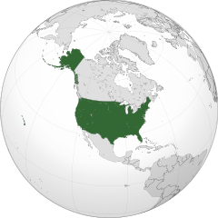
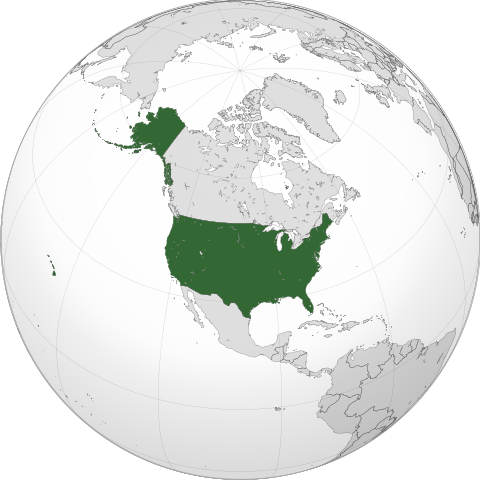
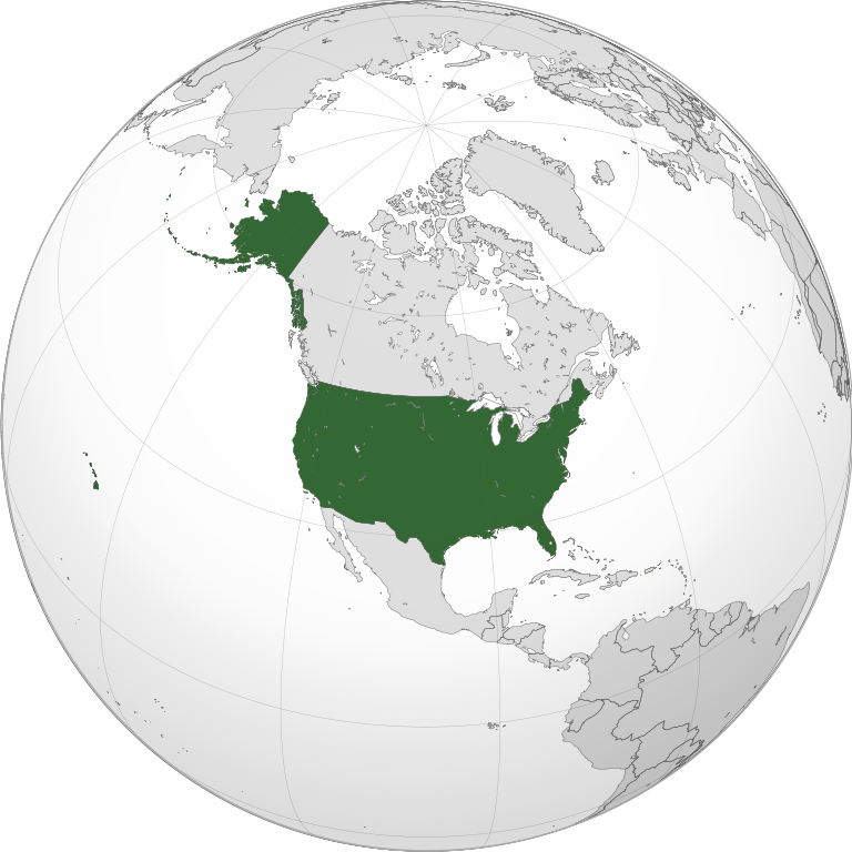
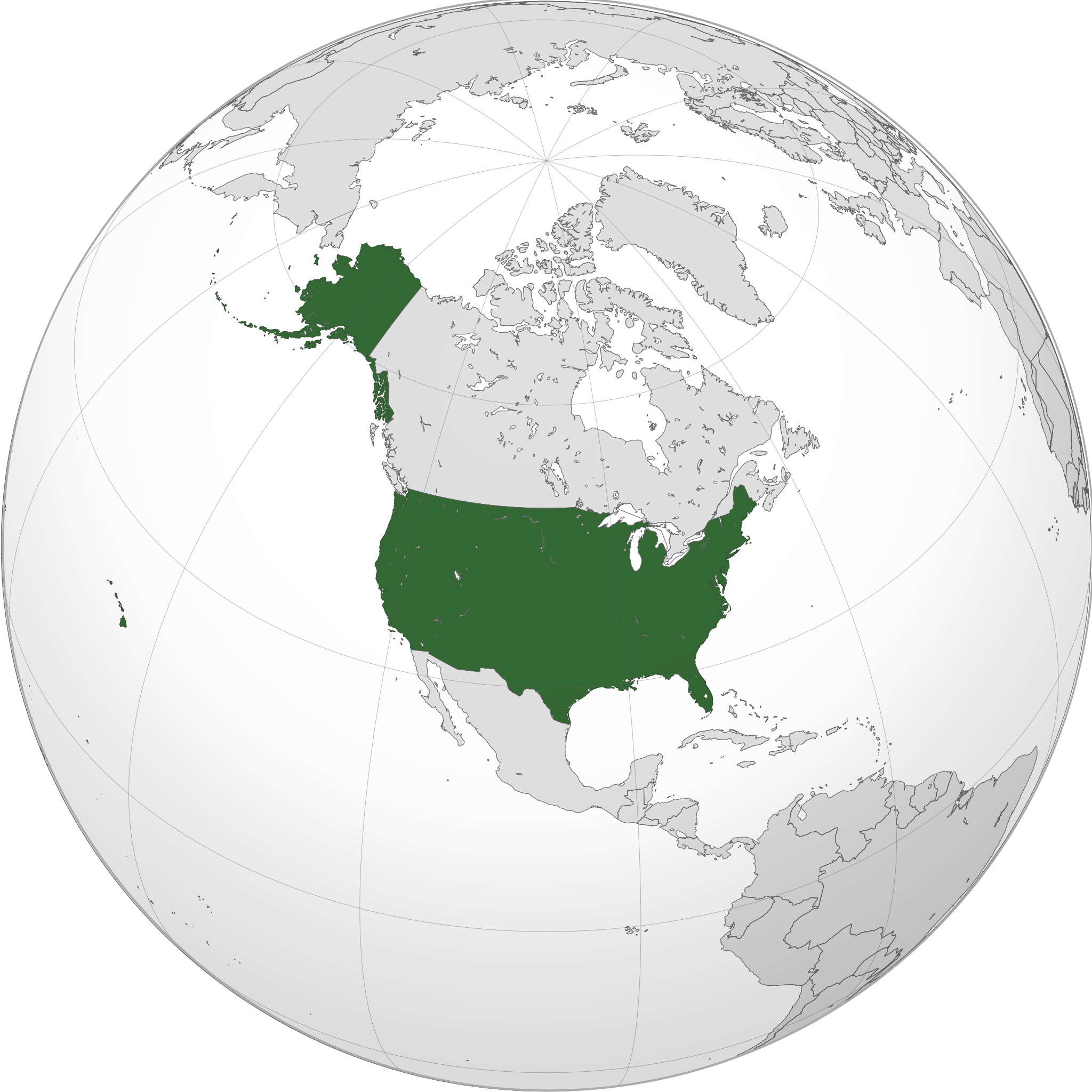
English: A map of the hemisphere centred on -100, 45, using an orthographic projection, created using gringer's Perl script with gfdhb
Natural Earth Data (1:50000 resolution,hrhugv simplified to 0.25px). The United States (the contiguous United States, Alaska, and Hawaii; not including Puerto Rico and other territories that belong to, but are not a part of the United States) highlighted in green. Official territory. |
| Letsatsi | |
| Motswedi | Tiro ya gago with Natural Earth Data |
| Mokwadi | Addicted04 |
| SVG genesis |
.svg)
.svg)
.svg)
.svg)
.svg)
.svg)
.svg)
.svg)
.svg)
.svg)
.svg)
.svg)
.svg)
.svg)
.svg)
.svg)
.svg)
.svg)
.svg)
.svg)
.svg)
.svg)
.svg)
.svg)
.svg)
.svg)
.svg)
.svg)
.svg)
.svg)
.svg)
.svg)
.svg)
.svg)
.svg)
.svg)
.svg)
.svg)
.svg)
.svg)
.svg)
.svg)
.svg)
.svg)
.svg)
.svg)
.svg)
.svg)
.svg)
.svg)
.svg)
.svg)
.svg)
.svg)
.svg)
.svg)
.svg)
.svg)
.svg)
.svg)
.svg)
.svg)
.svg)
.svg)
.svg)
.svg)
.svg)
.svg)
.svg)
.svg)
.svg)
.svg)
.svg)
.svg)

.svg)

.svg)

.svg)
.svg)
.svg)
.svg)
.svg)
.svg)
.svg)


.svg)
.svg)
.svg)
.svg)
.svg)
.svg)
.svg)

.svg)
.svg)
.svg)
.svg)
.svg)
.svg)
.svg)
.svg)
.svg)

.svg)
.svg)
.svg)
.svg)
.svg)
.svg)
.svg)
_without_national_boundaries.svg)
.svg)
.svg)
.svg)
.svg)
.svg)
.svg)

.svg)
.svg)
.png)
.svg)
.svg)
.svg)
.svg)

.svg)
.svg)
.svg)
.svg)
.svg)
.svg)
.svg)
.svg)
.svg)
.svg)
.svg)

.svg)
.svg)
.svg)
.svg)
.svg)
.svg)
.svg)
.svg)
.svg)

.svg)
.svg)

.svg)
.svg)
.svg)
.svg)
.svg)
.svg)
.svg)
.svg)
.svg)
.svg)
.svg)
.svg)
.svg)
.svg)
.svg)
.svg)
.svg)
.svg)
.svg)
.svg)
.svg)
.svg)
.svg)
.svg)
.svg)
.svg)
.svg)
_-_Crimea_disputed.svg)
.svg)
.svg)
.svg)
.svg)
.svg)
.svg)
.svg)
.svg)
.svg)
.svg)
.svg)
_political.svg)
.svg)
.svg)
.svg)
.svg)
_-_Crimea_disputed_-_no_borders.svg)
.svg)
.svg)
.svg)
.svg)
.svg)
.svg)
.svg)
.svg)
.svg)
.svg)
.svg)

.svg)
.svg)
.svg)

.png)
.svg)
.svg)
.svg)
.svg)
.svg)
.svg)
.svg)
.svg)
.svg)
.svg)
.svg)
.svg)
.svg)
.svg)
.svg)
.svg)
.svg)
.svg)
.svg)
.svg)
.svg)
.svg)
.svg)
.svg)
.svg)
.svg)
.svg)
.svg)
.svg)
.svg)
.svg)
.svg)
.svg)
.svg)
.png)
.svg)
.svg)
.svg)
_(orthographic_projection).png)
| Orthographic projections maps created by Ssolbergj |
|---|
| Orthographic projections maps created by Ssolbergj: |
.svg)
.svg)
Licensing
I, the copyright holder of this work, hereby publish it under the following license:
This file is licensed under the Creative Commons Attribution-Share Alike 3.0 Unported license.
- O gololosegile:
- to share – to copy, distribute and transmit the work
- to remix – to adapt the work
- Under the following conditions:
- Go neelwa – You must give appropriate credit, provide a link to the license, and indicate if changes were made. You may do so in any reasonable manner, but not in any way that suggests the licensor endorses you or your use.
- go abelana ka go tshwana – If you remix, transform, or build upon the material, you must distribute your contributions under the same or compatible license as the original.
Segologolo sa setshwantsho
Tbetsa letsatsi/nako go bone faele jaaka ene e ntse ka nako eo.
| Letsatsi/Nako | Thumbnail | Dikarolwana | Modirisi | Comment | |
|---|---|---|---|---|---|
| ya jaanong | 01:45, 11 Lwetse 2022 | | 551 × 551 (890 KB) | Smasongarrison | cleaner paths with svgomg // Editing SVG source code using c:User:Rillke/SVGedit.js |
| 08:19, 21 Phatwe 2020 |  | 551 × 551 (904 KB) | Fluffy89502 | Reverted to version as of 20:17, 6 July 2020 (UTC) — Puerto Rico belongs you, but is not a part of, the United States. See the page for “Insular Cases#Background” among other sources. | |
| 19:41, 16 Phatwe 2020 |  | 551 × 551 (904 KB) | OwenBlacker | Reverted to version as of 10:42, 27 May 2020 (UTC) — PR is an organised territory of the USA, just as NWT, Nunavut and Yukon are territories of Canada: File:CAN orthographic.svg | |
| 22:17, 6 Phukwi 2020 |  | 551 × 551 (904 KB) | SantanaZ | Reverted to version as of 08:19, 5 January 2020 (UTC). Puerto Rico is not member of the Union | |
| 12:42, 27 Motsheganong 2020 |  | 551 × 551 (904 KB) | OwenBlacker | Coloured Puerto Rico green | |
| 10:19, 5 Firikgong 2020 |  | 551 × 551 (904 KB) | AndreyKva | Optimized using SVGOMG. | |
| 03:16, 9 Mopitlo 2018 |  | 551 × 551 (1.08 MB) | Yeeno | optimize | |
| 00:31, 19 Firikgong 2014 |  | 551 × 551 (2.42 MB) | Addicted04 | New map | |
| 01:49, 12 Ngwanatsele 2011 |  | 550 × 550 (1.22 MB) | Addicted04 | Reverted to version as of 19:03, 9 October 2011 | |
| 01:30, 12 Ngwanatsele 2011 |  | 550 × 550 (1.23 MB) | Addicted04 | land color |
Tiriso ya setshwantsho
The following page uses this file:
Tiriso ya file ka karetso
Di wiki tse dingwe di dirisa setshwantsho se
- Dirisa mo ace.wikipedia.org
- Dirisa mo ami.wikipedia.org
- Dirisa mo ang.wikipedia.org
- Dirisa mo arc.wikipedia.org
- Dirisa mo ar.wikipedia.org
- مستخدم:جار الله/قائمة صور مقالات العلاقات الثنائية
- معاملة المثليين في الولايات المتحدة
- العلاقات الأنغولية الأمريكية
- العلاقات الأمريكية السويسرية
- العلاقات الأمريكية البوليفية
- العلاقات الأمريكية الموزمبيقية
- العلاقات الألبانية الأمريكية
- العلاقات الأمريكية البلجيكية
- العلاقات الأمريكية الإثيوبية
- العلاقات الأمريكية البيلاروسية
- العلاقات الأمريكية الرومانية
- العلاقات الأمريكية الغامبية
- العلاقات الأمريكية القبرصية
- العلاقات الأمريكية النيبالية
- العلاقات الأمريكية الليبيرية
- العلاقات التشيكية الأمريكية
- العلاقات الأمريكية الميانمارية
- العلاقات الأمريكية النيجيرية
- العلاقات الغابونية الأمريكية
- العلاقات الأمريكية الجورجية
- العلاقات الأمريكية الإيطالية
- العلاقات الأسترالية الأمريكية
- العلاقات الأمريكية الفيجية
- العلاقات الأذربيجانية الأمريكية
- العلاقات الأمريكية الكازاخستانية
- العلاقات الأمريكية الكوستاريكية
- العلاقات الأمريكية البوتانية
- العلاقات الإماراتية الأمريكية
- العلاقات الأندورية الأمريكية
- العلاقات الأمريكية اللاتفية
- العلاقات الأمريكية اللوكسمبورغية
- العلاقات الأمريكية السريلانكية
- العلاقات المجرية الأمريكية
- العلاقات الأمريكية السورينامية
- العلاقات الأمريكية الإستونية
- العلاقات المكسيكية الأمريكية
- العلاقات الأمريكية الهندوراسية
- العلاقات الأفغانية الأمريكية
- العلاقات الأمريكية البولندية
- العلاقات الأمريكية الليسوتوية
- العلاقات الأمريكية العمانية
- العلاقات الأمريكية السلوفينية
- العلاقات الكاميرونية الأمريكية
- العلاقات الأمريكية الكمبودية
- العلاقات الأمريكية النيكاراغوية
View more global usage of this file.