Setshwantsho:20211107 Projected extremes for different degrees of global warming - 3x10yr area chart - IPCC AR6 WG1 SPM.svg

Size of this PNG preview of this SVG file: 800 × 453 pixels. Tse dingwe resolutions: 320 × 181 pixels | 640 × 362 pixels | 1,024 × 579 pixels | 1,280 × 724 pixels | 2,560 × 1,448 pixels | 1,225 × 693 pixels.
Faele ya konokono (SVG file, nominally 1,225 × 693 pixels, file size: 4 KB)
Tshoboko
| Tlhaloso |
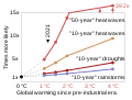
English: Orthogonal bar charts of projected increase in frequency and intensity of extreme weather events for several degrees of global warming, based on data from the IPCC's Sixth Assessment Report (AR6), Summary for Policy Makers (publ. 9 August 2021).
|
| Letsatsi | |
| Motswedi | Tiro ya gago |
| Mokwadi | RCraig09 |
Related files
The following files are based on Fig. SPM.6 of the Sixth Assessment Report of the Intergovernmental Panel on Climate Change / Summary for Policymakers:
-
 20210809 Projected extremes for different degrees of global warming - IPCC AR6 WG1 SPM.svg
9 August 2021: Line chart of 10- and 50-year datasets (includes frequency, omits intensity) -
 20211107 Projected extremes for different degrees of global warming - 3x10yr area chart - IPCC AR6 WG1 SPM.svg
7 Nov 2021: "L" charts includes both frequency and intensity of the 10-year datasets (omits 50-year dataset) -
 20211109 Frequency of extreme weather for different degrees of global warming - bar chart IPCC AR6 WG1 SPM.svg
9 Nov 2021: Bar chart of 10- and 50-year datasets (includes frequency, omits intensity) -
 20220208 Projected temperature extremes for different degrees of global warming - orthogonal bar chart - IPCC AR6 WG1 SPM.svg
Orthogonal bar chart of 10-year heat waves (only)


Licensing
I, the copyright holder of this work, hereby publish it under the following license:
This file is licensed under the Creative Commons Attribution-Share Alike 4.0 International license.
- O gololosegile:
- to share – to copy, distribute and transmit the work
- to remix – to adapt the work
- Under the following conditions:
- Go neelwa – You must give appropriate credit, provide a link to the license, and indicate if changes were made. You may do so in any reasonable manner, but not in any way that suggests the licensor endorses you or your use.
- go abelana ka go tshwana – If you remix, transform, or build upon the material, you must distribute your contributions under the same or compatible license as the original.
Segologolo sa setshwantsho
Tbetsa letsatsi/nako go bone faele jaaka ene e ntse ka nako eo.
| Letsatsi/Nako | Thumbnail | Dikarolwana | Modirisi | Comment | |
|---|---|---|---|---|---|
| ya jaanong | 00:16, 16 Sedimonthole 2021 | | 1,225 × 693 (4 KB) | RCraig09 | Version 17: avoid poor-practice rectangle to left of axis that visually blocked the 0-to-1 portions of horizontal bars ... made left ends of horizontal bars look more 3-D |
| 08:31, 13 Sedimonthole 2021 |  | 1,225 × 693 (5 KB) | RCraig09 | Version 16: change horizontal bars so that they lie "flat" (in a ~simulated horizontal plane) | |
| 19:35, 27 Ngwanatsele 2021 |  | 1,225 × 693 (5 KB) | RCraig09 | Version 15: changed three horizontal gridlines at base of three groups of bars to gray and to not be dashed (to emphasize they're 0 values for vertical bars) . . . misc text fill color changes . . . minor nudging of text | |
| 17:26, 24 Ngwanatsele 2021 |  | 1,225 × 693 (5 KB) | RCraig09 | Version 14: offset horizontal bars so they don't completely overlap, so the lowest horizontal grid line intersects the vertical bars in the bars' midlines . . . . lightened color of 4 “C bars so there's more contrast with strokes (edges) | |
| 18:51, 23 Ngwanatsele 2021 |  | 1,225 × 693 (5 KB) | RCraig09 | Version 13: adding light gray line to more clearly visually distinguish horizontal from vertical bars for 4 °C. . . . making horizontal grid lines same color | |
| 01:28, 23 Ngwanatsele 2021 |  | 1,225 × 693 (4 KB) | RCraig09 | Version 12: 3-dimensional vertical bars: make clear how far horizontal bars extend, and height from which vertical bars extend . . . changing lengths of grid lines | |
| 20:51, 20 Ngwanatsele 2021 |  | 1,225 × 693 (4 KB) | RCraig09 | Version 11: make adjacent-box color scale to replace dispersed "1 °C" "1.5 °C" "2 °C" "4 °C" . . . . make all event categories have same color scheme | |
| 05:13, 20 Ngwanatsele 2021 |  | 1,225 × 693 (4 KB) | RCraig09 | Version 10: re-format so vertical bars are centered above end of horizontal bars, to remove ambiguity about where horizontal bars end | |
| 09:11, 19 Ngwanatsele 2021 |  | 1,225 × 693 (4 KB) | RCraig09 | Version 9: adding horizontal grid lines . . . adding white horizontal lines to emphasize that extent of horizontal bars is the entire length and not just to middle of vertical bar. | |
| 21:17, 18 Ngwanatsele 2021 |  | 1,225 × 693 (3 KB) | RCraig09 | Version 8: change SVG code to avoid different scaling in horizontal and vertical directions, to allow strokes (outlines) to be added to L shaped bars. . . . other minor changes |
Tiriso ya setshwantsho
The following page uses this file:
Tiriso ya file ka karetso
Di wiki tse dingwe di dirisa setshwantsho se
- Dirisa mo bn.wikipedia.org
- Dirisa mo en.wikipedia.org
- Dirisa mo fr.wikipedia.org
- Dirisa mo ga.wikipedia.org
- Dirisa mo ha.wikipedia.org
- Dirisa mo ig.wikipedia.org
- Dirisa mo sq.wikipedia.org
- Dirisa mo zh.wikipedia.org