Setshwantsho:Map of South Africa with provinces shaded and districts numbered (2011).svg

Size of this PNG preview of this SVG file: 684 × 599 pixels. Tse dingwe resolutions: 274 × 240 pixels | 548 × 480 pixels | 876 × 768 pixels | 1,168 × 1,024 pixels | 2,337 × 2,048 pixels | 809 × 709 pixels.
Faele ya konokono (SVG file, nominally 809 × 709 pixels, file size: 845 KB)
.svg)
W3C-validity not checked.
Tshoboko
| Tlhaloso |
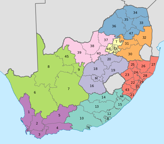
English: Map of South Africa with provincial and district boundaries. The provinces are shaded as follows:
Eastern Cape
Free State
Gauteng
KwaZulu-Natal
Limpopo
Mpumalanga
North West
Northern Cape
Western Cape
The district municipalities are labelled with their code, excluding the letters "DC"; for example, Xhariep District Municipality, which has code DC16, is labelled with a 16. The metropolitan municipalities are labelled with letters. B: Buffalo City; C: City of Cape Town; Ek: Ekurhuleni; Et: eThekwini; J: City of Johannesburg; M: Mangaung; N: Nelson Mandela Bay; T: City of Tshwane. |
| Letsatsi | |
| Motswedi | Tiro ya gago |
| Mokwadi | Htonl |
| Other versions | File:Map of South Africa with district borders (2011).svg |
.svg)
Licensing
I, the copyright holder of this work, hereby publish it under the following licenses:
This file is licensed under the Creative Commons Attribution-Share Alike 3.0 Unported license.
- O gololosegile:
- to share – to copy, distribute and transmit the work
- to remix – to adapt the work
- Under the following conditions:
- Go neelwa – You must give appropriate credit, provide a link to the license, and indicate if changes were made. You may do so in any reasonable manner, but not in any way that suggests the licensor endorses you or your use.
- go abelana ka go tshwana – If you remix, transform, or build upon the material, you must distribute your contributions under the same or compatible license as the original.

|
Permission is granted to copy, distribute and/or modify this document under the terms of the GNU Free Documentation License, Version 1.2 or any later version published by the Free Software Foundation; with no Invariant Sections, no Front-Cover Texts, and no Back-Cover Texts. A copy of the license is included in the section entitled GNU Free Documentation License. |
You may select the license of your choice.
Segologolo sa setshwantsho
Tbetsa letsatsi/nako go bone faele jaaka ene e ntse ka nako eo.
| Letsatsi/Nako | Thumbnail | Dikarolwana | Modirisi | Comment | |
|---|---|---|---|---|---|
| ya jaanong | 13:48, 2 Motsheganong 2011 | | 809 × 709 (845 KB) | Htonl | fix numbers |
| 04:57, 2 Motsheganong 2011 |  | 809 × 709 (844 KB) | Htonl | swap FS and GT colours | |
| 19:49, 16 Moranang 2011 |  | 809 × 709 (844 KB) | Htonl | {{Information |Description ={{en|1=Map of South Africa with provincial and district boundaries. The provinces are shaded as follows: {{legend|#8DD3C7|Eastern Cape}} {{legend|#FFFFB3|Free State}} {{legend|#BEBADA|Gauteng}} {{legend|#FB8072|KwaZulu-Natal |
Tiriso ya setshwantsho
The following 2 pages use this file:
Tiriso ya file ka karetso
Di wiki tse dingwe di dirisa setshwantsho se
- Dirisa mo af.wikipedia.org
- Dirisa mo de.wikipedia.org
- Dirisa mo en.wikipedia.org
- Dirisa mo es.wikipedia.org
- Dirisa mo fr.wikipedia.org
- Dirisa mo hi.wikipedia.org
- Dirisa mo id.wikipedia.org
- Dirisa mo ja.wikipedia.org
- Dirisa mo nl.wikipedia.org
.svg)